How to Use PondScan
Every function, step by step. Five minutes here saves you hours at the pond.
1 Install it like a real app
PondScan works right now in your browser — no install needed. Open catchmapapp.com, upload a pond screenshot, and you're fishing in 30 seconds. Add it to your Home Screen for full-screen + offline use:
- Open catchmapapp.com in Safari, then tap the Share button (the square with an up arrow, in Safari's bottom bar)
- Scroll down the share sheet and tap Add to Home Screen
- Tap Add — done. The PondScan icon launches full-screen and works offline
On Android: open the app in Chrome → tap the ⋮ menu → Add to Home screen → Install. Full walkthrough with screenshots on the install page.
⚙️ Alternate method: iOS configuration profile
Prefer the old profile shortcut? Grab it from the install page, then: tap Allow when Safari asks to download the profile → open Settings → Profile Downloaded → Install (your passcode is an Apple requirement for any profile). The profile only places a Home Screen shortcut — it requests no access to your data, and you can remove it anytime.
2 Your first scan (30 seconds)
- In Google Maps or Apple Maps, screenshot a pond (satellite view, zoomed so the pond fills most of the screen)
- Open PondScan → tap the big "Tap to upload pond" box → pick your screenshot
- Pick the pond type (see the next section) — the "Type: X — tap below to change" chip above the tiles always shows the active type
- Tap 🔍 Analyze Pond — the overlay renders in about 2 seconds (changed your mind mid-scan? Tap Cancel on the analysis overlay to stop it)
- No screenshot handy? Tap ⚡ Try a Sample Pond to see a real analysis instantly
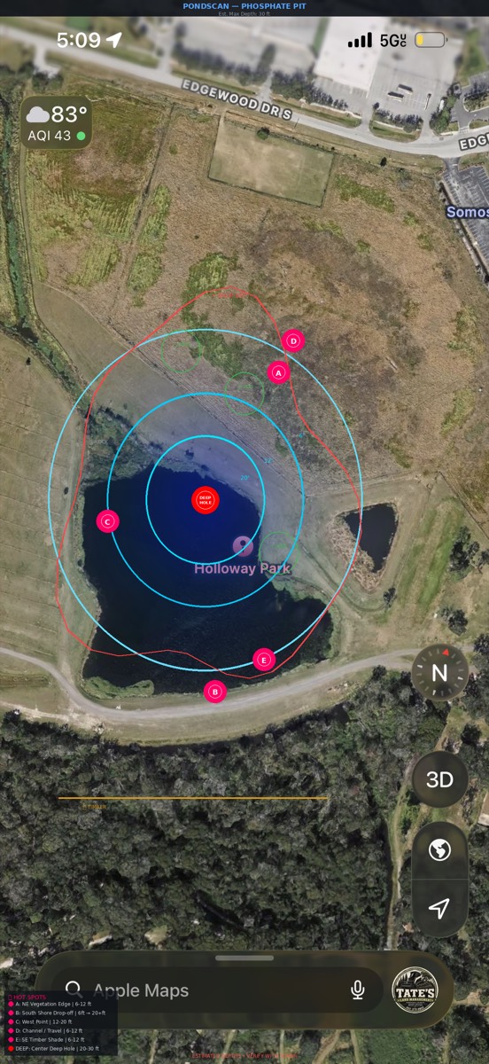
What a finished analysis looks like — depth zones, contour labels, drop-off ring, structure, and lettered hot spots.
3 Pond types (this choice matters)
Depth is estimated from geology, so pick the closest match. When in doubt, use Not Sure.
| Type | Max depth | What it means |
|---|---|---|
| ⛏️ Phosphate Pit | ~30 ft | Florida special. Steep walls, 3 ft → 20+ ft in yards |
| 🪨 Quarry | ~50 ft | Near-vertical walls. Fish the edges |
| 🏞️ Reservoir | ~18 ft | Gradual slopes, creek channels, roadbeds |
| 🌿 Natural Lake | ~12 ft | Weed edges, timber, variable bottom |
| 🚜 Farm Pond | ~10 ft | Bowl shape. Fish the dam face + any structure |
| 🕳️ Muck / Retention | ~8 ft | Shallow and murky — fish the outflow, culverts and riprap, slow and loud |
| 🏖️ Sand / Spring-fed | ~15 ft | Clear water over sand — finesse only: natural colors, light line, long casts |
| ❓ Not Sure | ~15 ft | General estimate when you're not sure |
4 Reading the map
Layers (toggle chips above the map)
- Depth — blue wash zones: dark blue = deep, light = shallow
- Contours — labeled depth lines (e.g. 6', 12', 20')
- Drop-off — red dashed ring where the bank falls fast. The bass highway
- Structure — vegetation (green): hydrilla, lily pads, eelgrass · timber (brown), rock (gray)
- Hot spots — lettered pins A–E plus the red DEEP hole marker
- Catches — gold pins: real logged catches, yours or imported
Zoom
Pinch, or use the + − buttons. ⌖ resets the view. When you're zoomed in, drag one finger to pan around the map.
5 Hot Spots (A–E + DEEP)
Every pin is a high-percentage location for that pond type. Tap 📍 Spots for the full card on each:
| Pin | What it is | Throw |
|---|---|---|
| A | Vegetation edge — ambush zone | Frog, buzzbait, flipping jig |
| B | Drop-off wall — travel route | Carolina rig, deep crank |
| C | Point with deep access | Jig, Texas rig |
| D | Channel / migration route | Spinnerbait, chatterbait |
| E | Timber shade — cooler water | Jig, Senko |
| DEEP | Center hole — thermal refuge | Drop shot, spoon |
🎣 Bank tactics — no boat? No problem
- Fan cast: from each bank position, make 5–7 casts in a fan — left to right — covering every lane before you move
- Cast parallel to the bank: a bait tracking along the shoreline edge stays in the strike zone the whole retrieve, instead of crossing it for two seconds
- Cover water, then move: bank-castable spots (~30–40 yd reach) reward mobility — fish the fan thoroughly, then walk 20–30 yards to the next angle instead of re-soaking one spot
- Hit the edge spots first: lettered spots A–E are bank-castable; the DEEP center hole is boat/kayak water — don't burn your best bank time on it
6 Season · Depth · Tackle tabs
Inside the Hot Spots sheet, tap between five tabs:
- Spots — the A–E cards
- Catches — imported + your logged catches (Big Fish toggle appears after import)
- Season — game plan with depth numbers for your pond type, split into four windows: Spring Feb–May, Summer Jun–Sep, Fall Oct–Nov, Winter Dec–Jan. Central Florida bass spawn Dec–Apr (peak Jan–Mar) — winter is bedding season here, not deep-and-dormant. May = shad spawn; fall = bass chasing shad and golden shiners shallow. Saved scans in 📋 History show their season-tune label (e.g. "🌡 Summer tune"); reopen an old scan and the sheet banner says what it was tuned for — if that window has passed you'll get an off-season warning ("it's now Fall — advice may be off-season")
- Depth — the full depth profile and how the estimate was made
- Tackle — lure picks by depth zone + color rules (clear water = natural, stained = dark, muddy = bright). Opens with a "Right now (season)" line tuned to today, and ends with Rigging Basics specs (Senko — 3/0 EWG hook, weightless · Speed Worm — 4/0 EWG hook, 1/8 oz bullet weight · Flipping Jig — ½ oz, 4/0 straight-shank hook) plus a per-pond "This Pond's Water" clarity note for your pond type
- 🖨 Print plan — the button at the bottom of the sheet prints all 5 tabs as a one-page trip plan, so the whole game plan travels on paper
7 Catches — log yours, import history
Log a catch
- Tap ➕ Log
- Species, length, weight, bait, location, notes → ✅ Log Catch (needs a size or bait to save)
- It drops a gold pin on your map and saves on your phone
Batch logging
After each save the toast asks "Catch logged! ✅ — next one?" — the form stays open and location + bait carry over to the next fish, so logging a limit takes seconds. Tap Done → when you're finished. Your catches draw as green ✓ pins on the map — toggle them with the My Catches chip above the map.
Import catch data (JSON)
- Tap 📁 Import Catch Data JSON and pick the file
- The analyze button switches to 🔍 Analyze with Catch Data — run it to overlay the imported catches on your scan
- The JSON looks like: {"lake":"Saddle Creek","catches":[{"angler":"will","species":"Largemouth bass","size":{"length_in":18,"weight_lb":3.2},"bait":"Senko","date":"4/12/2026"}]}
- Imported catches appear as gold pins with angler, size, bait, date — pin positions are approximate (the file has no GPS)
- Toggle 🐋 Big Fish Only to show only 3+ lb / 18"+ catches — instant trophy map
⇪ Export Catch Data (JSON) — backup & move phones
- Tap 📤 Export Catch Data (JSON) (in the Import Catch Data box on the upload screen) — it downloads pondscan-catches.json with every catch you've logged
- Keep that file as a backup, or AirDrop / message / email it to your other phone
- On the new phone, tap 📁 Import Catch Data JSON and pick the file — duplicates are skipped automatically, so re-importing the same file twice is safe
8 Save & History
- 💾 Save — on iPhone it opens the share sheet: save the annotated map straight to Photos or Files
- 🔄 New Scan — clears the current map and takes you back to upload a fresh screenshot
- 📋 History — your last 20 analyses with thumbnails. Tap one to reload it
- Welcome-back card — return to the app and the upload screen greets you with your scans · catches · season tip, plus a ▶ Resume last scan button that jumps straight back into your most recent analysis
✎ Managing your stuff
- Delete one scan: tap the ✕ on any item in 📋 History — an undo toast appears for 10 seconds; tap Undo to bring it right back
- Delete one catch: tap the ✕ on a catch in the Catches tab — same undo-on-delete toast safety net (imported catches are removed by re-importing a cleaned file)
- App updates: when the "New version ready — tap to refresh" banner shows up top, tap it to load the latest PondScan
- Delete catches: your catches live in your phone's browser storage. Clearing site data (Settings → Safari → Advanced → Website Data) removes them
- Re-run an analysis: tap ← Back from History, upload again, and pick a different pond type
- The install profile is just a Home Screen shortcut — remove it anytime by long-pressing the app icon
- iPhone only for install — on Android or desktop, the app works fine in the browser, no install needed
∑ Jargon, translated
Kids' First Fish 🧒 — handling, hooks & water safety
- Wet hands first
- Always wet your hands before touching a fish — dry hands strip the protective slime coat that keeps it healthy. Keep the fish over the water or a soft surface while you hold it.
- The lip grip
- For bass: grip the lower lip firmly with thumb inside the mouth and fingers curled under the jaw — it calms the fish and keeps your hands clear of the hooks. Support big fish horizontally with a second hand under the belly; never hang them vertically by the jaw alone.
- Barbless hooks
- Use barbless hooks or pinch the barb flat with pliers before a kid's trip. The fish comes unhooked in seconds, and a hook in a finger (or a kid) comes out cleanly too.
- Catch & release, right
- Unhook fast, minimize air time (under 10 seconds), and lower the fish back into the water — no tossing. If it's slow to recover, hold it upright facing into the current or move it gently side to side until it kicks away on its own.
- ⚠️ Water safety — pits & banks
- Phosphate pits and quarries have near-vertical walls: 3 ft of water can drop to 20+ ft a single step from shore, and the edges crumble. Keep kids an arm's length back from steep banks, in life jackets near deep pits, and never let them climb down pit walls to retrieve a snagged lure — cut the line instead.
- Florida licenses & kids
- Kids under 16 fish Florida fresh water license-free — no permit needed. Full rules, bag limits and licenses for everyone 16+: myfwc.com/fishing.
EWG, staging, secondary points, finesse, soundings, drop-off…
- EWG (hook)
- "Extra Wide Gap" worm hook — the wide bend lets a soft-plastic Senko or speed worm sit flat and still expose the point on the hookset. 3/0–4/0 covers most pond fishing.
- Staging
- When bass pause on the way to the shallows (pre-spawn) or on the way back out — they hold on the last deep cover before a flat instead of roaming open water.
- Secondary points
- The smaller points inside a cove or creek arm, not the main-lake points. Pre-spawn and post-spawn bass stop on these — classic staging real estate.
- Finesse
- The slow, subtle end of fishing: light line, small baits, little or no weight (drop shot, Ned rig, wacky Senko). Wins in clear water and when fish are pressured or cold.
- Soundings
- Individual depth readings on a chart or map — the "12 ft" numbers floating on the Lake maps page. One sounding = one measured spot, not a full contour.
- Drop-off
- Where the bottom falls away fast (say 3 ft → 15 ft in a few yards). Bass pin against it to ambush prey and slide up or down with the weather — the red dashed ring on your scan.
? FAQ
They're geology-based estimates, usually close enough to find the right water. Verify anything critical with a castable sonar.
Yes — after the first load, everything runs on your phone. Perfect for pits with no signal.
Nowhere. Screenshots, catches, and history never leave your device. Map tiles load from CARTO when online; everything else stays on your device.
Satellite view, pond filling most of the frame, labels off if possible. The clearer the waterline, the better the overlay.